Geolocate

Allisonia topographic map

Click on the map to display elevation.

About this map

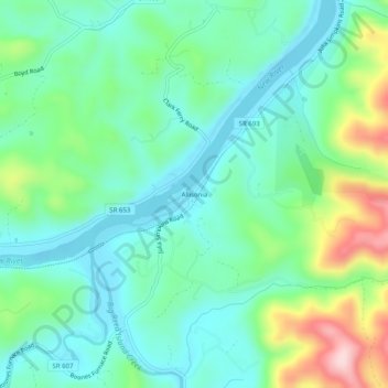
Name: Allisonia topographic map, elevation, terrain.

Location: Allisonia, Pulaski County, Virginia, United States (36.91929 -80.75618 36.95929 -80.71618)

Average elevation: 2,100 ft

Minimum elevation: 1,844 ft

Maximum elevation: 2,789 ft

Pulaski County trails, hiking, mountain biking, running and outdoor activities

Other topographic maps

Click on a map to view its topography, its elevation and its terrain.

Pulaski

United States > Virginia > Pulaski County

Average elevation: 2,133 ft

Hogan Lake

United States > Virginia > Pulaski County

Average elevation: 2,365 ft

Parrott

United States > Virginia > Pulaski County

Average elevation: 1,982 ft

Gear up for your next adventure:

🔦Powerful Headlamps - Ultra-bright hands-free lighting for night navigation
🚁Photography Drones - Capture stunning aerial views of landforms and topography
🥾Men's Hiking Boots - Durable, waterproof footwear for rugged terrain and steep inclines
🌄Hiking Binoculars - Compact binoculars for scenic views and trail spotting
🧭Hiking Compass - Precision compass for reliable navigation in the wilderness

As an Amazon Associate, this site earns from qualifying purchases at no extra cost to you.