
Make a donation
Gear up for your next adventure:
As an Amazon Associate, this site earns from qualifying purchases at no extra cost to you.
Maresme topographic map
Click on the map to display elevation.
Make a donation
Gear up for your next adventure:
As an Amazon Associate, this site earns from qualifying purchases at no extra cost to you.
About this map
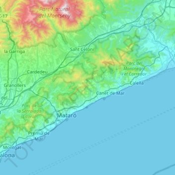
Name: Maresme topographic map, elevation, terrain.
Location: Maresme, Barcelona, Catalonia, Spain (41.46063 2.24695 41.74425 2.77800)
Average elevation: 623 ft
Minimum elevation: -3 ft
Maximum elevation: 5,459 ft
Make a donation
Gear up for your next adventure:
As an Amazon Associate, this site earns from qualifying purchases at no extra cost to you.
Other topographic maps
Click on a map to view its topography, its elevation and its terrain.
Make a donation
Gear up for your next adventure:
As an Amazon Associate, this site earns from qualifying purchases at no extra cost to you.
El Port de la Selva
Spain > Catalonia > Upper Empordà > el Port de la Selva > El Port de la Selva
Average elevation: 249 ft