Geolocate

Gariaband topographic map

Click on the map to display elevation.

Gariaband

Gariaband is Loceted on 20°38′N 82°03′E / 20.63°N 82.05°E / 20.63; 82.05. Gariaband has an average elevation of 318 metres (1043 ft).

Wikipedia (CC-BY-SA 3.0)

About this map

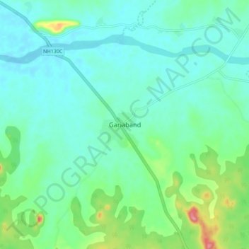
Name: Gariaband topographic map, elevation, terrain.

Location: Gariaband, Bindranavagarh(Gariyaband) Tahsil, Gariaband District, Chhattisgarh, 493889, India (20.59357 82.02354 20.67357 82.10354)

Average elevation: 1,135 ft

Minimum elevation: 1,056 ft

Maximum elevation: 1,421 ft

Gear up for your next adventure:

GPS Sports Watch - GPS watch for running, hiking and training
❄️Traction Cleats - Prevent slips on icy trails during winter hikes
🔭Telescopic Hiking Pole - Adjustable pole for hiking stability
🔋Rechargeable Batteries - Power up your outdoor devices
🍳Camping Cook Set - Complete cookware for outdoor meals

As an Amazon Associate, this site earns from qualifying purchases at no extra cost to you.