
Make a donation
Gear up for your next adventure:
As an Amazon Associate, this site earns from qualifying purchases at no extra cost to you.
Titisee topographic map
Click on the map to display elevation.
Make a donation
Gear up for your next adventure:
As an Amazon Associate, this site earns from qualifying purchases at no extra cost to you.
Titisee
Der Ortsteil Titisee von Titisee-Neustadt liegt am Nordufer des Titisees, im Osten des Feldbergs im Schwarzwald in 780 bis 1190 Meter Höhe. Der Ortsteil Neustadt befindet sich fünf Kilometer östlich davon. Die Stadt liegt an einem kleinen Fluss, der als Seebach vom Bärental kommend den Titisee speist, als Gutach (gute Ach) aus diesem fließt und östlich des Stadtteils Neustadt als reißender Fluss Wutach (wütende Ach) das Stadtgebiet wieder verlässt und sich durch die bekannte Wutachschlucht schließlich in den Rhein ergießt.
Make a donation
Gear up for your next adventure:
As an Amazon Associate, this site earns from qualifying purchases at no extra cost to you.
About this map
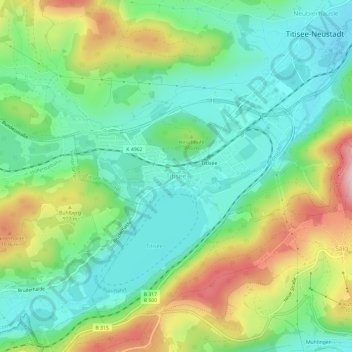
Name: Titisee topographic map, elevation, terrain.
Average elevation: 3,009 ft
Minimum elevation: 2,703 ft
Maximum elevation: 3,602 ft
Make a donation
Gear up for your next adventure:
As an Amazon Associate, this site earns from qualifying purchases at no extra cost to you.