
Pincher Station topographic map
Interactive map
Click on the map to display elevation.
About this map
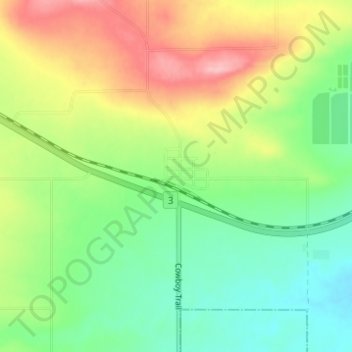
Name: Pincher Station topographic map, elevation, terrain.
Location: Pincher Station, Division No. 3, Alberta, T0K 1W0, Canada (49.50453 -113.96842 49.54453 -113.92842)
Average elevation: 3,812 ft
Minimum elevation: 3,642 ft
Maximum elevation: 4,078 ft
Other topographic maps
Click on a map to view its topography, its elevation and its terrain.
Waterton Lakes National Park
Canada > Alberta > Division No. 3
Waterton Lakes National Park, Division No. 3, Alberta, Canada
Average elevation: 5,833 ft
St. Mary Reservoir Provincial Recreation Area
Canada > Alberta > Division No. 3
St. Mary Reservoir Provincial Recreation Area, Township Road 50A, Division No. 3, Alberta, Canada
Average elevation: 3,612 ft
Fort Macleod
Canada > Alberta > Division No. 3 > Fort Macleod
Fort Macleod, 26 Street, Fort Macleod, Division No. 3, Alberta, T0L 0Z0, Canada
Average elevation: 3,104 ft
Stand Off
Canada > Alberta > Division No. 3
Stand Off, Division No. 3, Alberta, Canada
Average elevation: 3,320 ft
Beaver Mines
Canada > Alberta > Division No. 3
Beaver Mines, Division No. 3, Alberta, Canada
Average elevation: 4,413 ft
Mountain View
Canada > Alberta > Division No. 3
Mountain View, Division No. 3, Alberta, T0K 1N0, Canada
Average elevation: 4,321 ft
Claresholm
Canada > Alberta > Division No. 3
Claresholm, Division No. 3, Alberta, T0L 0T0, Canada
Average elevation: 3,383 ft