
Make a donation
Gear up for your next adventure:
As an Amazon Associate, this site earns from qualifying purchases at no extra cost to you.
Gildenhall topographic map
Click on the map to display elevation.
Make a donation
Gear up for your next adventure:
As an Amazon Associate, this site earns from qualifying purchases at no extra cost to you.
About this map
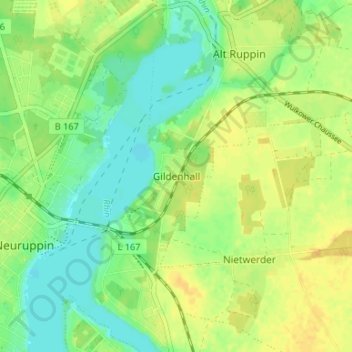
Name: Gildenhall topographic map, elevation, terrain.
Average elevation: 154 ft
Minimum elevation: 112 ft
Maximum elevation: 190 ft
Make a donation
Gear up for your next adventure:
As an Amazon Associate, this site earns from qualifying purchases at no extra cost to you.
Other topographic maps
Click on a map to view its topography, its elevation and its terrain.
Herrenhaus Gut Gentzrode
Deutschland > Brandenburg > Ostprignitz-Ruppin > Neuruppin
Die Gutsanlage Gentzrode liegt ca. 6 Kilometer nördlich von Neuruppin auf einer Höhe von 69 m ü. NHN und ca. 1,6 Kilometer westlich vom Tetzensee der in einer Glazialen Rinne des letzten Eiszeitalters liegt und vom Rhin durchflossenen wird.
Average elevation: 203 ft
Zermützelsee
Deutschland > Brandenburg > Ostprignitz-Ruppin > Neuruppin > Molchow
Average elevation: 187 ft
Make a donation
Gear up for your next adventure:
As an Amazon Associate, this site earns from qualifying purchases at no extra cost to you.
Lichtenberg
Deutschland > Brandenburg > Ostprignitz-Ruppin > Neuruppin
Der Ort liegt ca. 5 Kilometer südöstlich der Kernstadt Neuruppin an der Landesstraße L 167. Westlich erstreckt sich der 807 ha große Ruppiner See, östlich verläuft die L 164. Lichtenberg liegt auf einer Höhe von 60 m ü. NHN und der gesamte Ortsteil hat eine Ausdehnung von 12,9 km².
Average elevation: 157 ft
Make a donation
Gear up for your next adventure:
As an Amazon Associate, this site earns from qualifying purchases at no extra cost to you.