Geolocate

Otavi topographic map

Click on the map to display elevation.

About this map

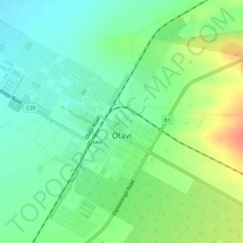
Name: Otavi topographic map, elevation, terrain.

Location: Otavi, Otjozondjupa, Namibia (-19.65778 17.31878 -19.62045 17.35041)

Average elevation: 4,646 ft

Minimum elevation: 4,587 ft

Maximum elevation: 4,744 ft

Other topographic maps

Click on a map to view its topography, its elevation and its terrain.

Okahandja

Namibia > Otjozondjupa

Average elevation: 4,423 ft

Otjiwarongo

Namibia > Otjozondjupa

Average elevation: 4,826 ft

Gear up for your next adventure:

🧭Compass with Lanyard - Easy‑carry compass for navigation
🩹Survival Bandages - High‑quality bandages for emergencies
🧣Hiking Neck Gaiter - Multi‑use neck protection for outdoor weather
🥾Hiking Shoes - Durable and comfortable shoes for trail hiking
🧭Outdoor Navigation Book - Learn advanced navigation skills

As an Amazon Associate, this site earns from qualifying purchases at no extra cost to you.