
Thank you for supporting this site ❤️
Make a donation
Make a donation
Gear up for your next adventure:
As an Amazon Associate, this site earns from qualifying purchases at no extra cost to you.
A Xesta topographic map
Click on the map to display elevation.
Thank you for supporting this site ❤️
Make a donation
Make a donation
Gear up for your next adventure:
As an Amazon Associate, this site earns from qualifying purchases at no extra cost to you.
About this map
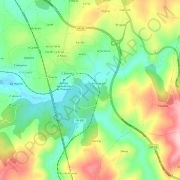
Name: A Xesta topographic map, elevation, terrain.
Location: A Xesta, Lalín, O Deza, Pontevedra, Galicia, 36515, Spain (42.58777 -8.13121 42.63161 -8.09160)
Average elevation: 1,864 ft
Minimum elevation: 1,532 ft
Maximum elevation: 2,339 ft
Thank you for supporting this site ❤️
Make a donation
Make a donation
Gear up for your next adventure:
As an Amazon Associate, this site earns from qualifying purchases at no extra cost to you.
Other topographic maps
Click on a map to view its topography, its elevation and its terrain.