
Make a donation
Gear up for your next adventure:
As an Amazon Associate, this site earns from qualifying purchases at no extra cost to you.
Bionnassay topographic map
Click on the map to display elevation.
Make a donation
Gear up for your next adventure:
As an Amazon Associate, this site earns from qualifying purchases at no extra cost to you.
Bionnassay
Bionnassay est un hameau d'altitude de France situé en Haute-Savoie, sur la commune de Saint-Gervais-les-Bains, dans une petite vallée latérale au val Montjoie, à 1 330 mètres d'altitude. Il se trouve au pied de la tête de la Charme et du col de Voza au nord et du mont Vorassay au sud.
Make a donation
Gear up for your next adventure:
As an Amazon Associate, this site earns from qualifying purchases at no extra cost to you.
About this map
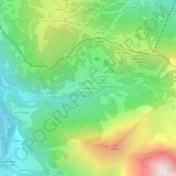
Name: Bionnassay topographic map, elevation, terrain.
Average elevation: 5,240 ft
Minimum elevation: 3,100 ft
Maximum elevation: 9,193 ft
Make a donation
Gear up for your next adventure:
As an Amazon Associate, this site earns from qualifying purchases at no extra cost to you.
Other topographic maps
Click on a map to view its topography, its elevation and its terrain.
Glacier de Miage
France > Auvergne-Rhône-Alpes > Haute-Savoie > Saint-Gervais-les-Bains
Average elevation: 9,003 ft
Bionnassay
France > Auvergne-Rhône-Alpes > Haute-Savoie > Saint-Gervais-les-Bains
Average elevation: 5,207 ft
Lac glaciaire de Bionnassay
France > Auvergne-Rhône-Alpes > Haute-Savoie > Saint-Gervais-les-Bains
Average elevation: 6,539 ft
Saint-Nicolas-de-Véroce
France > Auvergne-Rhône-Alpes > Haute-Savoie > Saint-Gervais-les-Bains
Average elevation: 5,115 ft
Make a donation
Gear up for your next adventure:
As an Amazon Associate, this site earns from qualifying purchases at no extra cost to you.
Le Planet
France > Auvergne-Rhône-Alpes > Haute-Savoie > Saint-Gervais-les-Bains > Le Planet
Average elevation: 5,394 ft