
Make a donation
Gear up for your next adventure:
As an Amazon Associate, this site earns from qualifying purchases at no extra cost to you.
Amai Manabilang topographic map
Click on the map to display elevation.
Make a donation
Gear up for your next adventure:
As an Amazon Associate, this site earns from qualifying purchases at no extra cost to you.
Amai Manabilang
Mountain ranges, hills, plateaus, and flatland characterize the topography of the barangay. It has a vast agricultural land suited for crops like rice, corn, carrots, sugar cane. Its hydrological features comprise rivers like the Maridugao and Sumogot, streams, swamps, creeks and springs.
Make a donation
Gear up for your next adventure:
As an Amazon Associate, this site earns from qualifying purchases at no extra cost to you.
About this map
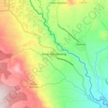
Name: Amai Manabilang topographic map, elevation, terrain.
Location: Amai Manabilang, Lanao del Sur, Bangsamoro, Philippines (7.74729 124.64186 7.82729 124.72186)
Average elevation: 3,179 ft
Minimum elevation: 1,706 ft
Maximum elevation: 5,174 ft
Make a donation
Gear up for your next adventure:
As an Amazon Associate, this site earns from qualifying purchases at no extra cost to you.
Other topographic maps
Click on a map to view its topography, its elevation and its terrain.