
Make a donation
Gear up for your next adventure:
As an Amazon Associate, this site earns from qualifying purchases at no extra cost to you.
Central City topographic map
Click on the map to display elevation.
Make a donation
Gear up for your next adventure:
As an Amazon Associate, this site earns from qualifying purchases at no extra cost to you.
Central City
Central City has the eighth-highest elevation of towns in Pennsylvania, at 2,200 feet (670 m).
Make a donation
Gear up for your next adventure:
As an Amazon Associate, this site earns from qualifying purchases at no extra cost to you.
About this map
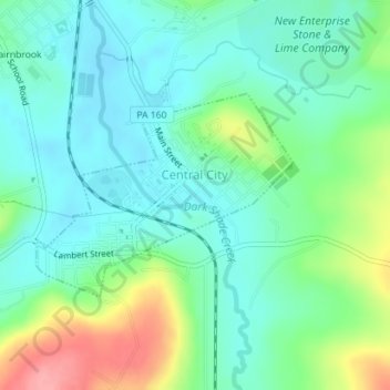
Name: Central City topographic map, elevation, terrain.
Location: Central City, Somerset County, Pennsylvania, United States (40.10214 -78.81631 40.11623 -78.79302)
Average elevation: 2,244 ft
Minimum elevation: 2,146 ft
Maximum elevation: 2,487 ft
Somerset County trails, hiking, mountain biking, running and outdoor activities
Make a donation
Gear up for your next adventure:
As an Amazon Associate, this site earns from qualifying purchases at no extra cost to you.
Other topographic maps
Click on a map to view its topography, its elevation and its terrain.
Cairnbrook
United States > Pennsylvania > Somerset County > Shade Township
Average elevation: 2,274 ft
Tire Hill
United States > Pennsylvania > Somerset County > Conemaugh Township
Average elevation: 1,529 ft
Barronvale
United States > Pennsylvania > Somerset County > Middlecreek Township
Average elevation: 1,982 ft
Make a donation
Gear up for your next adventure:
As an Amazon Associate, this site earns from qualifying purchases at no extra cost to you.
Zimmerman
United States > Pennsylvania > Somerset County > Somerset Township
Average elevation: 2,142 ft
2768 feet
United States > Pennsylvania > Somerset County > Jefferson Township
Average elevation: 2,661 ft
Make a donation
Gear up for your next adventure:
As an Amazon Associate, this site earns from qualifying purchases at no extra cost to you.