Geolocate

Bad Godesberg topographic map

Click on the map to display elevation.

About this map

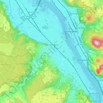
Name: Bad Godesberg topographic map, elevation, terrain.

Location: Bad Godesberg, Bonn, North Rhine-Westphalia, Germany (50.64249 7.10536 50.71772 7.21068)

Average elevation: 387 ft

Minimum elevation: 157 ft

Maximum elevation: 1,099 ft

Other topographic maps

Click on a map to view its topography, its elevation and its terrain.

Bonn

Germany > North Rhine-Westphalia > Bonn

Average elevation: 453 ft

Gear up for your next adventure:

💧Water Filtration Bottles - Safely drink from streams and lakes while exploring
🎒Hydration Pack - Hands‑free water reservoir for long hikes
🪶Fire Starter Kit - Reliable fire starter for survival and camping
🥾Women's Hiking Boots - Top-rated trail boots with ankle support and superior grip
👖Convertible Hiking Pants - Versatile zip-off pants for changing altitudes and temperatures

As an Amazon Associate, this site earns from qualifying purchases at no extra cost to you.