Geolocate

Loppersum topographic map

Click on the map to display elevation.

About this map

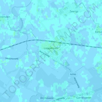
Name: Loppersum topographic map, elevation, terrain.

Location: Loppersum, Eemsdelta, Groningen, Netherlands (53.31102 6.70328 53.35041 6.77494)

Average elevation: 0 ft

Minimum elevation: -7 ft

Maximum elevation: 13 ft

Other topographic maps

Click on a map to view its topography, its elevation and its terrain.

Blokstad

Netherlands > Groningen > Appingedam > Blokstad

Average elevation: -3 ft

Gear up for your next adventure:

👖Convertible Hiking Pants - Versatile zip-off pants for changing altitudes and temperatures
🧭Pro Hiking Compasses - High-accuracy liquid-filled compasses for topographic orientation
🛰️Handheld GPS Units - Professional satellite navigators for precise backcountry mapping
🧺Microfiber Travel Towels - Compact and fast-drying towels for trail use
🧤Hiking Gloves - Protective gloves for rugged trails

As an Amazon Associate, this site earns from qualifying purchases at no extra cost to you.