
Thank you for supporting this site ❤️
Make a donation
Make a donation
Gear up for your next adventure:
As an Amazon Associate, this site earns from qualifying purchases at no extra cost to you.
Bandipora topographic map
Click on the map to display elevation.
Thank you for supporting this site ❤️
Make a donation
Make a donation
Gear up for your next adventure:
As an Amazon Associate, this site earns from qualifying purchases at no extra cost to you.
About this map
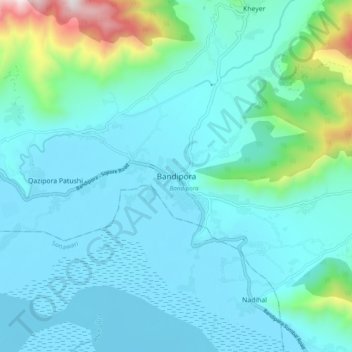
Name: Bandipora topographic map, elevation, terrain.
Location: Bandipora, Bandipore, Jammu and Kashmir, 193502, India (34.38324 74.59597 34.46324 74.67597)
Average elevation: 5,719 ft
Minimum elevation: 5,164 ft
Maximum elevation: 8,960 ft
Thank you for supporting this site ❤️
Make a donation
Make a donation
Gear up for your next adventure:
As an Amazon Associate, this site earns from qualifying purchases at no extra cost to you.