
Make a donation
Gear up for your next adventure:
As an Amazon Associate, this site earns from qualifying purchases at no extra cost to you.
Lawrenceburg topographic map
Click on the map to display elevation.
Make a donation
Gear up for your next adventure:
As an Amazon Associate, this site earns from qualifying purchases at no extra cost to you.
Lawrenceburg
The city of Lawrenceburg has a total area of 12.6 square miles (33 km2). It is the largest city on the state line between Chattanooga and Memphis. Located on the southern Highland Rim, Lawrence County and Lawrenceburg are set atop of a large mountain plateau of the Appalachian Mountain range with elevations ranging between 810 feet (250 m) to over 1,120 feet (340 m). Map of the Appalachian Mountain Range.
Make a donation
Gear up for your next adventure:
As an Amazon Associate, this site earns from qualifying purchases at no extra cost to you.
About this map
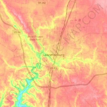
Name: Lawrenceburg topographic map, elevation, terrain.
Average elevation: 925 ft
Minimum elevation: 686 ft
Maximum elevation: 1,040 ft
Lawrence County trails, hiking, mountain biking, running and outdoor activities
Make a donation
Gear up for your next adventure:
As an Amazon Associate, this site earns from qualifying purchases at no extra cost to you.
Other topographic maps
Click on a map to view its topography, its elevation and its terrain.
Make a donation
Gear up for your next adventure:
As an Amazon Associate, this site earns from qualifying purchases at no extra cost to you.
Lawrenceburg
United States > Tennessee > Lawrence County > Lawrenceburg
The city of Lawrenceburg has a total area of 12.6 square miles (33 km2). It is the largest city on the state line between Chattanooga and Memphis. Located on the southern Highland Rim, Lawrence County and Lawrenceburg are set atop of a large mountain plateau of the Appalachian Mountain range with elevations…
Average elevation: 912 ft