
Make a donation
Gear up for your next adventure:
As an Amazon Associate, this site earns from qualifying purchases at no extra cost to you.
Rubiás topographic map
Click on the map to display elevation.
Make a donation
Gear up for your next adventure:
As an Amazon Associate, this site earns from qualifying purchases at no extra cost to you.
About this map
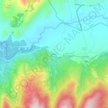
Name: Rubiás topographic map, elevation, terrain.
Average elevation: 3,176 ft
Minimum elevation: 2,730 ft
Maximum elevation: 4,157 ft
Make a donation
Gear up for your next adventure:
As an Amazon Associate, this site earns from qualifying purchases at no extra cost to you.
Other topographic maps
Click on a map to view its topography, its elevation and its terrain.
Make a donation
Gear up for your next adventure:
As an Amazon Associate, this site earns from qualifying purchases at no extra cost to you.
Sandiás
El relieve del término municipal está caracterizado por la tierra desecada de la antigua laguna de Antela por el este y por las elevaciones que hacen de límite occidental de la comarca de La Limia, que alcanzan los 892 metros en el pico Cantariñas por el oeste. La altitud oscila entre los 892 metros al…
Average elevation: 2,169 ft