
Make a donation
Gear up for your next adventure:
As an Amazon Associate, this site earns from qualifying purchases at no extra cost to you.
Bhola District topographic map
Click on the map to display elevation.
Make a donation
Gear up for your next adventure:
As an Amazon Associate, this site earns from qualifying purchases at no extra cost to you.
About this map
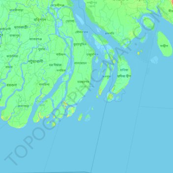
Name: Bhola District topographic map, elevation, terrain.
Location: Bhola District, Barishal Division, Bangladesh (21.42660 90.40299 22.86290 91.03116)
Average elevation: 7 ft
Minimum elevation: -10 ft
Maximum elevation: 135 ft
Make a donation
Gear up for your next adventure:
As an Amazon Associate, this site earns from qualifying purchases at no extra cost to you.
Other topographic maps
Click on a map to view its topography, its elevation and its terrain.
Make a donation
Gear up for your next adventure:
As an Amazon Associate, this site earns from qualifying purchases at no extra cost to you.
Make a donation
Gear up for your next adventure:
As an Amazon Associate, this site earns from qualifying purchases at no extra cost to you.
Pond of Reshot Ali house
Bangladesh > Barishal Division > Borhanuddin Subdistrict
Average elevation: 16 ft
Make a donation
Gear up for your next adventure:
As an Amazon Associate, this site earns from qualifying purchases at no extra cost to you.
Mehendiganj
Bangladesh > Barishal Division > Mehendiganj Subdistrict > Mehendiganj
Average elevation: 13 ft
Pond Of Sofiq Maowlana
Bangladesh > Barishal Division > Borhanuddin Subdistrict
Average elevation: 13 ft