
Sinseong-dong topographic map
Interactive map
Click on the map to display elevation.
About this map
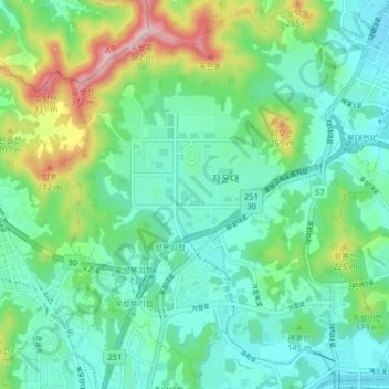
Name: Sinseong-dong topographic map, elevation, terrain.
Location: Sinseong-dong, Yuseong-gu, Daejeon, South Korea (36.37181 127.32275 36.43558 127.40314)
Average elevation: 364 ft
Minimum elevation: 89 ft
Maximum elevation: 1,158 ft
Other topographic maps
Click on a map to view its topography, its elevation and its terrain.
Seattle Park
Seattle Park, Dunsan-dong, Dunsan 1(il)-dong, Seo-gu, Daejeon, South Korea
Average elevation: 167 ft
Jayang-dong
South Korea > Daejeon > Jayang-dong
Jayang-dong, Dong-gu, Daejeon, South Korea
Average elevation: 315 ft
Hyo-dong
South Korea > Daejeon > Hyo-dong
Hyo-dong, Dong-gu, Daejeon, South Korea
Average elevation: 358 ft