Geolocate

Furi topographic map

Click on the map to display elevation.

Furi

Furi is an alpine hamlet in the Pennine Alps, located three kilometers south of Zermatt, Switzerland at an altitude of 1,687m. It is located on a relatively flat area of land between the Gornera and Zmuttbach rivers.

Wikipedia (CC-BY-SA 3.0)

About this map

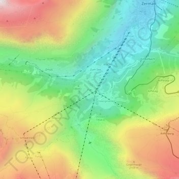
Name: Furi topographic map, elevation, terrain.

Location: Furi, Zermatt, Visp, Wallis, 3920, Switzerland (45.98196 7.71020 46.02196 7.75020)

Average elevation: 7,238 ft

Minimum elevation: 5,262 ft

Maximum elevation: 10,115 ft

Other topographic maps

Click on a map to view its topography, its elevation and its terrain.

Gorner Glacier

Switzerland > Wallis > Visp > Zermatt

Average elevation: 10,430 ft

Gornera

Switzerland > Wallis > Visp > Zermatt

Average elevation: 7,303 ft

Gear up for your next adventure:

🧺Microfiber Travel Towels - Compact and fast-drying towels for trail use
📦Dry Bags Set - Waterproof storage for electronics and clothes
📷Action Cameras - Rugged cameras to document your journeys across rugged terrain
📻Weather Alert Radios - Stay informed of storm risks while off-the-grid
🛠️Outdoor Gear Repair Kit - Essential tools to fix gear on the trail

As an Amazon Associate, this site earns from qualifying purchases at no extra cost to you.