
Make a donation
Gear up for your next adventure:
As an Amazon Associate, this site earns from qualifying purchases at no extra cost to you.
San Rafael Calería topographic map
Click on the map to display elevation.
Make a donation
Gear up for your next adventure:
As an Amazon Associate, this site earns from qualifying purchases at no extra cost to you.
About this map
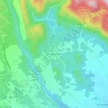
Name: San Rafael Calería topographic map, elevation, terrain.
Location: San Rafael Calería, Córdoba, Veracruz, 94500, México (18.92000 -96.96444 18.96000 -96.92444)
Average elevation: 3,241 ft
Minimum elevation: 2,867 ft
Maximum elevation: 4,373 ft
Make a donation
Gear up for your next adventure:
As an Amazon Associate, this site earns from qualifying purchases at no extra cost to you.
Other topographic maps
Click on a map to view its topography, its elevation and its terrain.
Parque 21 de Mayo
México > Veracruz > Córdoba > Córdoba > Barrio de San Miguel
Average elevation: 2,825 ft
Alameda Rafael Murillo Vidal
México > Veracruz > Córdoba > Córdoba > Toxpan Indeco
Average elevation: 2,835 ft
Make a donation
Gear up for your next adventure:
As an Amazon Associate, this site earns from qualifying purchases at no extra cost to you.