
Make a donation
Gear up for your next adventure:
As an Amazon Associate, this site earns from qualifying purchases at no extra cost to you.
Booitshoeke topographic map
Click on the map to display elevation.
Make a donation
Gear up for your next adventure:
As an Amazon Associate, this site earns from qualifying purchases at no extra cost to you.
Booitshoeke
Booitshoeke ligt in het West-Vlaams poldergebied op een hoogte van ongeveer 2,5 meter. De belangrijkste waterlopen zijn de Koolhofvaart en de Proostdijkvaart. In het noordwesten doorsnijdt de autoweg A18 het landelijke gebied.
Make a donation
Gear up for your next adventure:
As an Amazon Associate, this site earns from qualifying purchases at no extra cost to you.
About this map
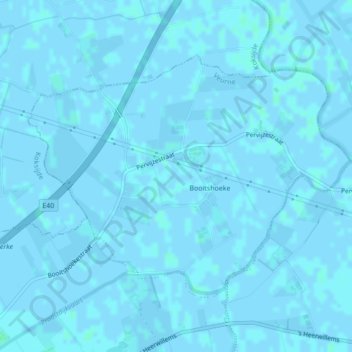
Name: Booitshoeke topographic map, elevation, terrain.
Location: Booitshoeke, Veurne, West-Vlaanderen, België (51.07915 2.72196 51.09777 2.76138)
Average elevation: 0 ft
Minimum elevation: -7 ft
Maximum elevation: 10 ft
Make a donation
Gear up for your next adventure:
As an Amazon Associate, this site earns from qualifying purchases at no extra cost to you.
Other topographic maps
Click on a map to view its topography, its elevation and its terrain.
Westhoekduinen, duinen van Cabour, De Moeren en plateau van Izenberge
België > West-Vlaanderen > Veurne > Veurne
Average elevation: 3 ft
Make a donation
Gear up for your next adventure:
As an Amazon Associate, this site earns from qualifying purchases at no extra cost to you.