Geolocate

Lea topographic map

Click on the map to display elevation.

About this map

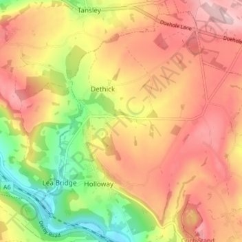
Name: Lea topographic map, elevation, terrain.

Location: Lea, Dethick, Lea and Holloway CP, Dethick, Amber Valley, Derbyshire, East Midlands, England, DE4 5GR, United Kingdom (53.09333 -1.52943 53.13333 -1.48943)

Average elevation: 666 ft

Minimum elevation: 243 ft

Maximum elevation: 981 ft

Other topographic maps

Click on a map to view its topography, its elevation and its terrain.

Gear up for your next adventure:

🧭Map Reading Tools - Tools and kits for map navigation
🧢Sun Protection Hats - Wide-brimmed and UPF-rated hats for high-altitude sun safety
🪶Fire Starter Kit - Reliable fire starter for survival and camping
🪶Compact Camp Shovel - Folding shovel for campsite tasks
🥩Freeze-Dried Meals - Nutritious and lightweight food for remote expeditions

As an Amazon Associate, this site earns from qualifying purchases at no extra cost to you.