
Make a donation
Gear up for your next adventure:
As an Amazon Associate, this site earns from qualifying purchases at no extra cost to you.
Inawayan topographic map
Click on the map to display elevation.
Make a donation
Gear up for your next adventure:
As an Amazon Associate, this site earns from qualifying purchases at no extra cost to you.
About this map
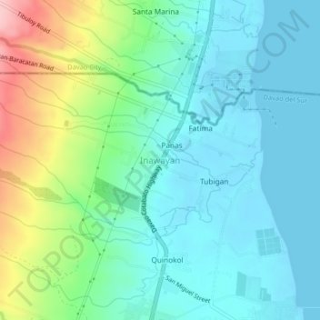
Name: Inawayan topographic map, elevation, terrain.
Location: Inawayan, Davao del Sur, Davao Region, Philippines (6.93924 125.45513 6.97924 125.49513)
Average elevation: 131 ft
Minimum elevation: 0 ft
Maximum elevation: 597 ft
Make a donation
Gear up for your next adventure:
As an Amazon Associate, this site earns from qualifying purchases at no extra cost to you.
Other topographic maps
Click on a map to view its topography, its elevation and its terrain.
Santa Cruz
Santa Cruz is traversed by mountain ranges and high relief that include part of Mount Apo, the highest mountain peak in the Philippines, straddle the south, central, north and north-western portions of the municipality. The rugged topography of the central area gradually undulates toward the coastal plains of…
Average elevation: 1,181 ft
Make a donation
Gear up for your next adventure:
As an Amazon Associate, this site earns from qualifying purchases at no extra cost to you.