
Make a donation
Gear up for your next adventure:
As an Amazon Associate, this site earns from qualifying purchases at no extra cost to you.
Städten topographic map
Click on the map to display elevation.
Make a donation
Gear up for your next adventure:
As an Amazon Associate, this site earns from qualifying purchases at no extra cost to you.
About this map
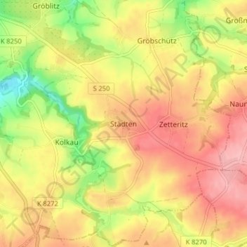
Name: Städten topographic map, elevation, terrain.
Average elevation: 814 ft
Minimum elevation: 594 ft
Maximum elevation: 974 ft
Make a donation
Gear up for your next adventure:
As an Amazon Associate, this site earns from qualifying purchases at no extra cost to you.
Other topographic maps
Click on a map to view its topography, its elevation and its terrain.
Köttern
Deutschland > Sachsen > Mittelsachsen > Seelitz
Köttern liegt im Norden der Großgemeinde Seelitz auf einer Höhe zwischen den Tälern des Leitebachs im Norden und des der Aubachs im Süden, welche beide in die Zwickauer Mulde münden. Südöstlich des Orts befindet sich der Kötterner Porschel, der nach dem Ort benannt ist. An Köttern führt südlich die…
Average elevation: 699 ft