
Thank you for supporting this site ❤️
Make a donation
Make a donation
Gear up for your next adventure:
As an Amazon Associate, this site earns from qualifying purchases at no extra cost to you.
Cəlilabad topographic map
Click on the map to display elevation.
Thank you for supporting this site ❤️
Make a donation
Make a donation
Gear up for your next adventure:
As an Amazon Associate, this site earns from qualifying purchases at no extra cost to you.
About this map
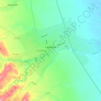
Name: Cəlilabad topographic map, elevation, terrain.
Location: Cəlilabad, Jalilabad District, Lankaran-Astara, Azerbaijan (39.18223 48.46209 39.23350 48.56134)
Average elevation: 108 ft
Minimum elevation: -10 ft
Maximum elevation: 371 ft
Thank you for supporting this site ❤️
Make a donation
Make a donation
Gear up for your next adventure:
As an Amazon Associate, this site earns from qualifying purchases at no extra cost to you.