
Malham topographic map
Click on the map to display elevation.
Malham
Malham has an Oceanic climate, but is generally colder and wetter than most settlements in Britain. It has a relatively low altitude of around 200 metres, but is partly surrounded by fells. This exposed position means the temperature range is limited, due to little pooling of cold air. Extremes of temperature (since 1960) range from 28.2 °C (82.8 °F) during August 1990, down to −13.5 °C (7.7 °F) during March 2001.
About this map
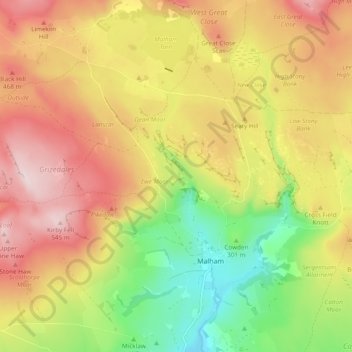
Name: Malham topographic map, elevation, terrain.
Average elevation: 1,188 ft
Minimum elevation: 584 ft
Maximum elevation: 1,788 ft
Other topographic maps
Click on a map to view its topography, its elevation and its terrain.
Easby Moor
United Kingdom > England > North Yorkshire > Easby > Little Ayton
Average elevation: 604 ft
Swinithwaite
United Kingdom > England > North Yorkshire > Richmondshire > West Witton > Swinithwaite
Average elevation: 673 ft
Cayton Bay
United Kingdom > England > North Yorkshire > Scarborough > Osgodby
Average elevation: 115 ft
Bolton Castle
United Kingdom > England > North Yorkshire > Redmire > Castle Bolton
Average elevation: 820 ft
Thimbleby & Osmotherly Show field
United Kingdom > England > North Yorkshire > Thimbleby
Average elevation: 499 ft
Killinghall
United Kingdom > England > North Yorkshire > Harrogate > Killinghall
Average elevation: 282 ft