
Make a donation
Gear up for your next adventure:
As an Amazon Associate, this site earns from qualifying purchases at no extra cost to you.
Ashdown Gorge Wilderness topographic map
Click on the map to display elevation.
Make a donation
Gear up for your next adventure:
As an Amazon Associate, this site earns from qualifying purchases at no extra cost to you.
Ashdown Gorge Wilderness
The wilderness is within the Dixie National Forest adjacent to Cedar Breaks National Monument and characterized by extremely steep-walled canyons cut through the west rim of the Markagunt Plateau. Elevations in the wilderness range from 10,500 feet (3,200 m) to 7,500 feet (2,300 m). Rattlesnake Creek and Ashdown Creek flow through the wilderness. The 7,043 acres (28.5 km2) wilderness area was designated by the U.S. Congress in 1984 and is administered is by the United States Forest Service.
Make a donation
Gear up for your next adventure:
As an Amazon Associate, this site earns from qualifying purchases at no extra cost to you.
About this map
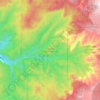
Name: Ashdown Gorge Wilderness topographic map, elevation, terrain.
Location: Ashdown Gorge Wilderness, Iron County, Utah, United States (37.59708 -112.91987 37.68692 -112.84080)
Average elevation: 8,907 ft
Minimum elevation: 6,995 ft
Maximum elevation: 10,971 ft
Make a donation
Gear up for your next adventure:
As an Amazon Associate, this site earns from qualifying purchases at no extra cost to you.
Other topographic maps
Click on a map to view its topography, its elevation and its terrain.
Make a donation
Gear up for your next adventure:
As an Amazon Associate, this site earns from qualifying purchases at no extra cost to you.