
Griffith Park topographic map
Click on the map to display elevation.
About this map
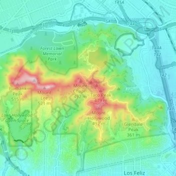
Name: Griffith Park topographic map, elevation, terrain.
Average elevation: 725 ft
Minimum elevation: 397 ft
Maximum elevation: 1,749 ft
Los Angeles County trails, hiking, mountain biking, running and outdoor activities
Other topographic maps
Click on a map to view its topography, its elevation and its terrain.
San Fernando Valley
United States > California > Los Angeles County > Los Angeles
Average elevation: 1,627 ft
Universal City Overlook
United States > California > Los Angeles County > Los Angeles
Average elevation: 912 ft
San Fernando Valley
United States > California > Los Angeles County > Los Angeles
Average elevation: 1,627 ft
Santa Susana Mountains
United States > California > Los Angeles County > Los Angeles
Average elevation: 1,706 ft
South Los Angeles
United States > California > Los Angeles County > Los Angeles
Average elevation: 1,381 ft
Will Rogers State Historic Park
United States > California > Los Angeles County > Los Angeles
Average elevation: 499 ft
El Escorpion Park
United States > California > Los Angeles County > Los Angeles
Average elevation: 1,119 ft
San Fernando Valley
United States > California > Los Angeles County > Los Angeles
Average elevation: 1,627 ft
Exposition Park
United States > California > Los Angeles County > Los Angeles
Average elevation: 180 ft
Rio de Los Angeles State Park State Recreational Area
United States > California > Los Angeles County > Los Angeles
Average elevation: 463 ft