
Make a donation
Gear up for your next adventure:
As an Amazon Associate, this site earns from qualifying purchases at no extra cost to you.
San Fernando Valley topographic map
Click on the map to display elevation.
Make a donation
Gear up for your next adventure:
As an Amazon Associate, this site earns from qualifying purchases at no extra cost to you.
About this map
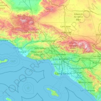
Name: San Fernando Valley topographic map, elevation, terrain.
Average elevation: 1,627 ft
Minimum elevation: 0 ft
Maximum elevation: 9,836 ft
Los Angeles County trails, hiking, mountain biking, running and outdoor activities
Make a donation
Gear up for your next adventure:
As an Amazon Associate, this site earns from qualifying purchases at no extra cost to you.
Other topographic maps
Click on a map to view its topography, its elevation and its terrain.
Sherman Oaks Neighborhood Council District
United States > California > Los Angeles County > Los Angeles
Average elevation: 843 ft
Valley Village Neighborhood Council District
United States > California > Los Angeles County > Los Angeles
Average elevation: 653 ft
Studio City Neighborhood Council District
United States > California > Los Angeles County > Los Angeles
Average elevation: 837 ft
Make a donation
Gear up for your next adventure:
As an Amazon Associate, this site earns from qualifying purchases at no extra cost to you.
Canoga Park Neighborhood Council District
United States > California > Los Angeles County > Los Angeles
Average elevation: 837 ft
Porter Ranch Neighborhood Council District
United States > California > Los Angeles County > Los Angeles
Average elevation: 1,509 ft
Van Nuys Neighborhood Council District
United States > California > Los Angeles County > Los Angeles
Average elevation: 735 ft
Make a donation
Gear up for your next adventure:
As an Amazon Associate, this site earns from qualifying purchases at no extra cost to you.
Winnetka Neighborhood Council District
United States > California > Los Angeles County > Los Angeles
Average elevation: 801 ft
Chatsworth Neighborhood Council District
United States > California > Los Angeles County > Los Angeles
Average elevation: 1,181 ft
North Hollywood Neighborhood Council District
United States > California > Los Angeles County > Los Angeles
Average elevation: 643 ft
Make a donation
Gear up for your next adventure:
As an Amazon Associate, this site earns from qualifying purchases at no extra cost to you.
Encino Neighborhood Council District
United States > California > Los Angeles County > Los Angeles
Average elevation: 945 ft
Pacoima Neighborhood Council
United States > California > Los Angeles County > Los Angeles
Average elevation: 1,024 ft
Pacific Palisades
United States > California > Los Angeles County > Los Angeles
Pacific Palisades was formally founded in 1921 by a Methodist organization, and in the years that followed became a refuge for Jewish artists and intellectuals fleeing the Holocaust. The Palisades would later be sought after by celebrities and other high-profile individuals seeking privacy. It is known for its…
Average elevation: 643 ft
Make a donation
Gear up for your next adventure:
As an Amazon Associate, this site earns from qualifying purchases at no extra cost to you.
Little Ethopia
United States > California > Los Angeles County > Los Angeles
Average elevation: 157 ft
Sherman Oaks Neighborhood Council District
United States > California > Los Angeles County > Los Angeles
Average elevation: 843 ft
Little Ethopia
United States > California > Los Angeles County > Los Angeles
Average elevation: 157 ft
Will Rogers State Historic Park
United States > California > Los Angeles County > Los Angeles
Average elevation: 499 ft
Make a donation
Gear up for your next adventure:
As an Amazon Associate, this site earns from qualifying purchases at no extra cost to you.
Valley Village Neighborhood Council District
United States > California > Los Angeles County > Los Angeles
Average elevation: 653 ft
Chatsworth Neighborhood Council District
United States > California > Los Angeles County > Los Angeles
Average elevation: 1,181 ft
Make a donation
Gear up for your next adventure:
As an Amazon Associate, this site earns from qualifying purchases at no extra cost to you.
El Escorpion Park
United States > California > Los Angeles County > Los Angeles
Average elevation: 1,119 ft
Make a donation
Gear up for your next adventure:
As an Amazon Associate, this site earns from qualifying purchases at no extra cost to you.
Chatsworth Neighborhood Council District
United States > California > Los Angeles County > Los Angeles
Average elevation: 1,184 ft
Van Nuys Neighborhood Council District
United States > California > Los Angeles County > Los Angeles
Average elevation: 735 ft
Chatsworth Neighborhood Council District
United States > California > Los Angeles County > Los Angeles
Average elevation: 1,181 ft
Make a donation
Gear up for your next adventure:
As an Amazon Associate, this site earns from qualifying purchases at no extra cost to you.
Los Angeles City Council District 11
United States > California > Los Angeles County > Los Angeles
Average elevation: 463 ft
North Hollywood Neighborhood Council District
United States > California > Los Angeles County > Los Angeles
Average elevation: 643 ft
Make a donation
Gear up for your next adventure:
As an Amazon Associate, this site earns from qualifying purchases at no extra cost to you.
Chatsworth Neighborhood Council District
United States > California > Los Angeles County > Los Angeles
Average elevation: 1,181 ft
Aliso Canyon Park
United States > California > Los Angeles County > Los Angeles
Average elevation: 1,378 ft
Hollywood Hills
United States > California > Los Angeles County > Los Angeles
Average elevation: 794 ft
Make a donation
Gear up for your next adventure:
As an Amazon Associate, this site earns from qualifying purchases at no extra cost to you.
Los Angeles City Council District 7
United States > California > Los Angeles County > Los Angeles
Average elevation: 1,680 ft
Exposition Park
United States > California > Los Angeles County > Los Angeles
Average elevation: 180 ft
Make a donation
Gear up for your next adventure:
As an Amazon Associate, this site earns from qualifying purchases at no extra cost to you.
Rio de Los Angeles State Park State Recreational Area
United States > California > Los Angeles County > Los Angeles
Average elevation: 463 ft