Geolocate

May Pen topographic map

Click on the map to display elevation.

About this map

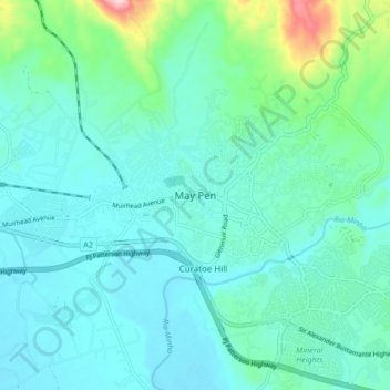
Name: May Pen topographic map, elevation, terrain.

Location: May Pen, Clarendon, Middlesex County, Jamaica (17.93464 -77.29820 18.01464 -77.21820)

Average elevation: 289 ft

Minimum elevation: 115 ft

Maximum elevation: 1,152 ft

Other topographic maps

Click on a map to view its topography, its elevation and its terrain.

Belle Plain

Jamaica > Clarendon

Average elevation: 151 ft

Gear up for your next adventure:

👖Convertible Hiking Pants - Versatile zip-off pants for changing altitudes and temperatures
🪶Wildlife Field Guides - Learn animal tracking and species ID
🎒Outdoor Daypacks - Lightweight backpacks designed for carrying maps and essential gear
📚USA Hiking Guide Books - Top trail guides and map books
🧯Emergency Survival Kit - All‑in‑one survival essentials for the backcountry

As an Amazon Associate, this site earns from qualifying purchases at no extra cost to you.