Geolocate

Balitoc topographic map

Click on the map to display elevation.

About this map

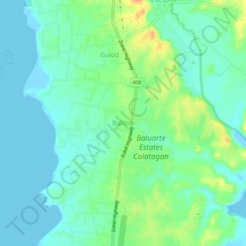
Name: Balitoc topographic map, elevation, terrain.

Location: Balitoc, Calatagan, Batangas, Calabarzon, 4215, Philippines (13.84522 120.61594 13.88522 120.65594)

Average elevation: 46 ft

Minimum elevation: -13 ft

Maximum elevation: 256 ft

Other topographic maps

Click on a map to view its topography, its elevation and its terrain.

Burot Beach

Philippines > Batangas > Calatagan

Average elevation: 10 ft

Pagapas Bay

Philippines > Batangas > Calatagan

Average elevation: 49 ft

Gear up for your next adventure:

🧭Orienteering Set - Complete compass and map reading kit
🪑Portable Camp Table - Compact table for campsite meals
🔥Camping Stove - Portable stove for camping and backcountry cooking
👖Convertible Hiking Pants - Versatile zip-off pants for changing altitudes and temperatures
📦Dry Bags Set - Waterproof storage for electronics and clothes

As an Amazon Associate, this site earns from qualifying purchases at no extra cost to you.