Geolocate

Louisa topographic map

Click on the map to display elevation.

About this map

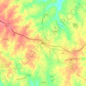
Name: Louisa topographic map, elevation, terrain.

Location: Louisa, Louisa County, Virginia, United States (37.98504 -78.04357 38.06504 -77.96357)

Average elevation: 427 ft

Minimum elevation: 272 ft

Maximum elevation: 554 ft

Gear up for your next adventure:

🎁Geography Themed Gifts - Unique gift ideas for map lovers and geography enthusiasts
🪶Trail Camera - Capture wildlife on your hikes
📶Satellite Messenger - Communication device off‑grid
🌡️Handheld Weather Meters - Measure wind, temp, and pressure for safe mountain travel
Solar GPS Watches - Advanced multisport watches with built-in topographic maps

As an Amazon Associate, this site earns from qualifying purchases at no extra cost to you.