
Make a donation
Gear up for your next adventure:
As an Amazon Associate, this site earns from qualifying purchases at no extra cost to you.
Macandamine topographic map
Click on the map to display elevation.
Make a donation
Gear up for your next adventure:
As an Amazon Associate, this site earns from qualifying purchases at no extra cost to you.
About this map
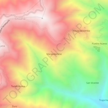
Name: Macandamine topographic map, elevation, terrain.
Location: Macandamine, Parroquia Utuana, Calvas, Loja, Ecuador (-4.39515 -79.71654 -4.35515 -79.67654)
Average elevation: 6,673 ft
Minimum elevation: 4,350 ft
Maximum elevation: 8,517 ft
Make a donation
Gear up for your next adventure:
As an Amazon Associate, this site earns from qualifying purchases at no extra cost to you.
Other topographic maps
Click on a map to view its topography, its elevation and its terrain.
Parroquia Cariamanga
Cariamanga, también conocida como San Pedro Mártir de Cariamanga, es una ciudad ecuatoriana; cabecera cantonal del Cantón Calvas, así como la tercera urbe más grande y poblada de la Provincia de Loja. Se localiza al sur de la Región interandina del Ecuador, asentada en una meseta baja de la cordillera…
Average elevation: 5,381 ft