
Make a donation
Gear up for your next adventure:
As an Amazon Associate, this site earns from qualifying purchases at no extra cost to you.
Le Locle topographic map
Click on the map to display elevation.
Make a donation
Gear up for your next adventure:
As an Amazon Associate, this site earns from qualifying purchases at no extra cost to you.
Le Locle
En raison de l'altitude (près de 1 000 m) et de l'hydrologie (sol karstique), le terrain est peu propice à l'agriculture. La planification et les bâtiments reflètent le besoin d'organisation rationnelle des artisans horlogers. Ils ont été reconstruits au début du XIXe siècle, après de graves incendies.
Make a donation
Gear up for your next adventure:
As an Amazon Associate, this site earns from qualifying purchases at no extra cost to you.
About this map
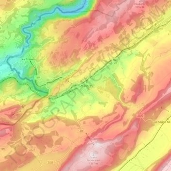
Name: Le Locle topographic map, elevation, terrain.
Location: Le Locle, Neuchâtel, 2400, Suisse (47.01559 6.70545 47.09559 6.78545)
Average elevation: 3,465 ft
Minimum elevation: 2,287 ft
Maximum elevation: 4,364 ft
Make a donation
Gear up for your next adventure:
As an Amazon Associate, this site earns from qualifying purchases at no extra cost to you.