
Make a donation
Gear up for your next adventure:
As an Amazon Associate, this site earns from qualifying purchases at no extra cost to you.
Gönningen topographic map
Click on the map to display elevation.
Make a donation
Gear up for your next adventure:
As an Amazon Associate, this site earns from qualifying purchases at no extra cost to you.
About this map
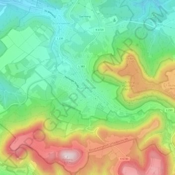
Name: Gönningen topographic map, elevation, terrain.
Average elevation: 1,995 ft
Minimum elevation: 1,480 ft
Maximum elevation: 2,812 ft
Make a donation
Gear up for your next adventure:
As an Amazon Associate, this site earns from qualifying purchases at no extra cost to you.
Other topographic maps
Click on a map to view its topography, its elevation and its terrain.
Reutlingen-Betzingen
Deutschland > Baden-Württemberg > Landkreis Reutlingen > Reutlingen
Average elevation: 1,234 ft
Sondelfingen
Deutschland > Baden-Württemberg > Landkreis Reutlingen > Reutlingen
Average elevation: 1,322 ft
Oferdingen
Deutschland > Baden-Württemberg > Landkreis Reutlingen > Reutlingen
Average elevation: 1,125 ft
Make a donation
Gear up for your next adventure:
As an Amazon Associate, this site earns from qualifying purchases at no extra cost to you.
Reicheneck
Deutschland > Baden-Württemberg > Landkreis Reutlingen > Reutlingen
Average elevation: 1,181 ft
Altenburg
Deutschland > Baden-Württemberg > Landkreis Reutlingen > Reutlingen
Die auf der Anhöhe am Nordende des Dorfes stehende Kirche wurde 1654, anstelle einer dem heiligen Nikolaus durch Bischof Werner von Straßburg geweihten Kapelle, errichtet. Ihr heutiger Bau entstammt teilweise dem 11. Jahrhundert. Beide Glocken wurden 1837 von Christian Adam Kurtz und Sohn in Reutlingen…
Average elevation: 1,161 ft
Rommelsbach
Deutschland > Baden-Württemberg > Landkreis Reutlingen > Reutlingen
Average elevation: 1,211 ft
Make a donation
Gear up for your next adventure:
As an Amazon Associate, this site earns from qualifying purchases at no extra cost to you.