
Make a donation
Gear up for your next adventure:
As an Amazon Associate, this site earns from qualifying purchases at no extra cost to you.
La Prairie topographic map
Click on the map to display elevation.
Make a donation
Gear up for your next adventure:
As an Amazon Associate, this site earns from qualifying purchases at no extra cost to you.
About this map
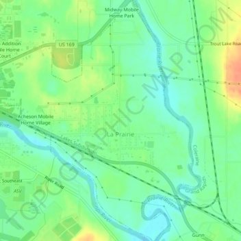
Name: La Prairie topographic map, elevation, terrain.
Location: La Prairie, Itasca County, Minnesota, United States (47.21527 -93.51222 47.24452 -93.47496)
Average elevation: 1,289 ft
Minimum elevation: 1,237 ft
Maximum elevation: 1,371 ft
Make a donation
Gear up for your next adventure:
As an Amazon Associate, this site earns from qualifying purchases at no extra cost to you.
Other topographic maps
Click on a map to view its topography, its elevation and its terrain.
Make a donation
Gear up for your next adventure:
As an Amazon Associate, this site earns from qualifying purchases at no extra cost to you.
Twin Lake Trails Mobile Home Park
United States > Minnesota > Itasca County
Average elevation: 1,375 ft