
Make a donation
Gear up for your next adventure:
As an Amazon Associate, this site earns from qualifying purchases at no extra cost to you.
Tadjenanet topographic map
Click on the map to display elevation.
Make a donation
Gear up for your next adventure:
As an Amazon Associate, this site earns from qualifying purchases at no extra cost to you.
Tadjenanet
Tadjenanet se situe à 75 km au sud-ouest de Mila et à 18 km de Chelghoum Laïd sur la RN 5 reliant Alger à Constantine. A une altitude de 850 m, elle est arrosée d'Ouest en Est par l'Oued Rhumel. À 10 km au ٍSud, se trouve la forêt d'Ouled Abdennour adossée au Djebel Rokbet ank Djmal. Elle se situe à 75 km de Constantine, 96 km de Batna,56 km de Sétif et enfin à 23 km de la ville d'El Eulma, connue pour son marché de gros qui génère d'importants flux commerciaux.
Make a donation
Gear up for your next adventure:
As an Amazon Associate, this site earns from qualifying purchases at no extra cost to you.
About this map
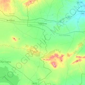
Name: Tadjenanet topographic map, elevation, terrain.
Location: Tadjenanet, Daïra Tadjenanet, Mila, Algérie (35.89061 5.91506 36.20567 6.10639)
Average elevation: 2,995 ft
Minimum elevation: 2,480 ft
Maximum elevation: 4,564 ft
Make a donation
Gear up for your next adventure:
As an Amazon Associate, this site earns from qualifying purchases at no extra cost to you.