Geolocate

Baldo topographic map

Click on the map to display elevation.

About this map

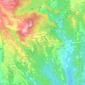
Name: Baldo topographic map, elevation, terrain.

Location: Baldo, Masserano, Biella, Piemonte, 13866, Italia (45.57429 8.19666 45.61429 8.23666)

Average elevation: 1,037 ft

Minimum elevation: 758 ft

Maximum elevation: 1,444 ft

Gear up for your next adventure:

🪶Compact Camp Shovel - Folding shovel for campsite tasks
🧭Pro Hiking Compasses - High-accuracy liquid-filled compasses for topographic orientation
🪄Magnetic Compass - Accurate compass for navigation
🩹Survival Bandages - High‑quality bandages for emergencies
⛑️Personal Locator Beacon - Safety beacon for emergencies

As an Amazon Associate, this site earns from qualifying purchases at no extra cost to you.