
Town of Wilton topographic map
Interactive map
Click on the map to display elevation.
About this map
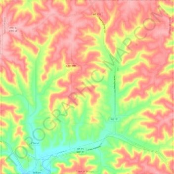
Name: Town of Wilton topographic map, elevation, terrain.
Average elevation: 1,243 ft
Minimum elevation: 958 ft
Maximum elevation: 1,457 ft
Other topographic maps
Click on a map to view its topography, its elevation and its terrain.
Town of Sparta
United States > Wisconsin > Monroe County
Town of Sparta, Monroe County, Wisconsin, 54656, United States
Average elevation: 912 ft
Town of Clifton
United States > Wisconsin > Monroe County
Town of Clifton, Monroe County, Wisconsin, United States
Average elevation: 1,109 ft
Oakdale
United States > Wisconsin > Monroe County
Oakdale, Monroe County, Wisconsin, 54649, United States
Average elevation: 942 ft
Town of Wellington
United States > Wisconsin > Monroe County
Town of Wellington, Monroe County, Wisconsin, United States
Average elevation: 1,220 ft
Warrens
United States > Wisconsin > Monroe County
Warrens, Monroe County, Wisconsin, United States
Average elevation: 1,014 ft
Wilton
United States > Wisconsin > Monroe County
Wilton, Monroe County, Wisconsin, United States
Average elevation: 1,053 ft
Cashton
United States > Wisconsin > Monroe County
Cashton, Monroe County, Wisconsin, United States
Average elevation: 1,332 ft
Mill Bluff State Park
United States > Wisconsin > Monroe County
Mill Bluff State Park, Town of Oakdale, Monroe County, Wisconsin, United States
Average elevation: 942 ft
Sparta
United States > Wisconsin > Monroe County
Sparta, Monroe County, Wisconsin, United States
Average elevation: 843 ft