
Thank you for supporting this site ❤️
Make a donation
Make a donation
Gear up for your next adventure:
As an Amazon Associate, this site earns from qualifying purchases at no extra cost to you.
Hahnenkamm topographic map
Click on the map to display elevation.
Thank you for supporting this site ❤️
Make a donation
Make a donation
Gear up for your next adventure:
As an Amazon Associate, this site earns from qualifying purchases at no extra cost to you.
Hahnenkamm
Über Kitzbühel erhebt sich der Hahnenkamm mit einer Höhe von 1712 m ü. A. Der eigentlich höchste Punkt am Hahnenkamm ist die Ehrenbachhöhe mit einer Höhe von 1802 m ü. A.
Thank you for supporting this site ❤️
Make a donation
Make a donation
Gear up for your next adventure:
As an Amazon Associate, this site earns from qualifying purchases at no extra cost to you.
About this map
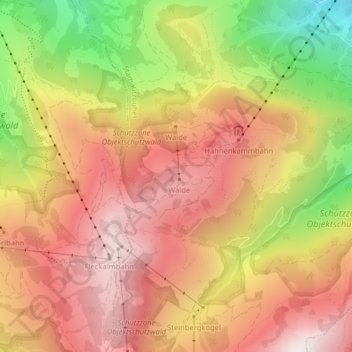
Name: Hahnenkamm topographic map, elevation, terrain.
Average elevation: 4,724 ft
Minimum elevation: 2,907 ft
Maximum elevation: 5,961 ft
Thank you for supporting this site ❤️
Make a donation
Make a donation
Gear up for your next adventure:
As an Amazon Associate, this site earns from qualifying purchases at no extra cost to you.