
Thank you for supporting this site ❤️
Make a donation
Make a donation
Gear up for your next adventure:
As an Amazon Associate, this site earns from qualifying purchases at no extra cost to you.
Tabacundo topographic map
Click on the map to display elevation.
Thank you for supporting this site ❤️
Make a donation
Make a donation
Gear up for your next adventure:
As an Amazon Associate, this site earns from qualifying purchases at no extra cost to you.
About this map
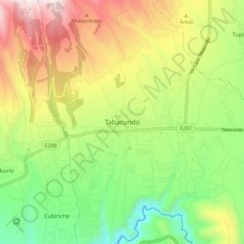
Name: Tabacundo topographic map, elevation, terrain.
Location: Tabacundo, Cantón Pedro Moncayo, Pichincha, 171004, Ecuador (0.00820 -78.26164 0.08820 -78.18164)
Average elevation: 9,541 ft
Minimum elevation: 8,022 ft
Maximum elevation: 11,585 ft
Thank you for supporting this site ❤️
Make a donation
Make a donation
Gear up for your next adventure:
As an Amazon Associate, this site earns from qualifying purchases at no extra cost to you.
Other topographic maps
Click on a map to view its topography, its elevation and its terrain.