
Make a donation
Gear up for your next adventure:
As an Amazon Associate, this site earns from qualifying purchases at no extra cost to you.
Usar topographic map
Click on the map to display elevation.
Make a donation
Gear up for your next adventure:
As an Amazon Associate, this site earns from qualifying purchases at no extra cost to you.
About this map
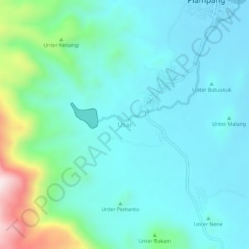
Name: Usar topographic map, elevation, terrain.
Average elevation: 440 ft
Minimum elevation: 89 ft
Maximum elevation: 1,939 ft
Make a donation
Gear up for your next adventure:
As an Amazon Associate, this site earns from qualifying purchases at no extra cost to you.
Other topographic maps
Click on a map to view its topography, its elevation and its terrain.
Lombok Tengah
Indonesia > West Nusa Tenggara
Central Lombok has a tropical climate with long dry seasons. The rain season normally commences in October and continues until April with an average rainfall of above 100mm during these months. In December falls have reached 382 mm. From May until September average rainfall is below 100 mm with the lowest…
Average elevation: 948 ft