
Make a donation
Gear up for your next adventure:
As an Amazon Associate, this site earns from qualifying purchases at no extra cost to you.
Groede topographic map
Click on the map to display elevation.
Make a donation
Gear up for your next adventure:
As an Amazon Associate, this site earns from qualifying purchases at no extra cost to you.
Groede
Groede ligt in het zeekleipoldergebied op een hoogte van ongeveer 1,5 meter. De omgeving kent vooral akkerbouw. Aan de kust vindt men -naast grootschalig toerisme- ook natuurgebieden zoals de Groedse Duintjes. Ten zuiden van Groede liggen kreken zoals de Baarzandse Kreek en de Nieuwerkerkse Kreek. Hier vindt men ook de Kasteelberg Groede, een historische vliedberg. In het oosten ligt nog de Nieuwlandse Kreek.
Make a donation
Gear up for your next adventure:
As an Amazon Associate, this site earns from qualifying purchases at no extra cost to you.
About this map
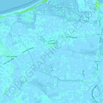
Name: Groede topographic map, elevation, terrain.
Location: Groede, Sluis, Zeeland, Nederland (51.34713 3.46558 51.40253 3.54846)
Average elevation: 0 ft
Minimum elevation: -13 ft
Maximum elevation: 26 ft
Make a donation
Gear up for your next adventure:
As an Amazon Associate, this site earns from qualifying purchases at no extra cost to you.
Other topographic maps
Click on a map to view its topography, its elevation and its terrain.
Make a donation
Gear up for your next adventure:
As an Amazon Associate, this site earns from qualifying purchases at no extra cost to you.
Make a donation
Gear up for your next adventure:
As an Amazon Associate, this site earns from qualifying purchases at no extra cost to you.
Make a donation
Gear up for your next adventure:
As an Amazon Associate, this site earns from qualifying purchases at no extra cost to you.
Make a donation
Gear up for your next adventure:
As an Amazon Associate, this site earns from qualifying purchases at no extra cost to you.
Make a donation
Gear up for your next adventure:
As an Amazon Associate, this site earns from qualifying purchases at no extra cost to you.
Make a donation
Gear up for your next adventure:
As an Amazon Associate, this site earns from qualifying purchases at no extra cost to you.
Sint Anna ter Muiden
Sint Anna ter Muiden ligt in het zeekleipoldergebied op een hoogte van ongeveer 1,5 meter. In de omgeving vindt men diverse historische polderdijken die ook de Belgisch-Nederlandse grens overschrijden. In het zuiden ligt de Damse Vaart en in het nabijgelegen België vindt men kreken en overblijfselen van de…
Average elevation: 3 ft
Make a donation
Gear up for your next adventure:
As an Amazon Associate, this site earns from qualifying purchases at no extra cost to you.
Make a donation
Gear up for your next adventure:
As an Amazon Associate, this site earns from qualifying purchases at no extra cost to you.
Make a donation
Gear up for your next adventure:
As an Amazon Associate, this site earns from qualifying purchases at no extra cost to you.
Make a donation
Gear up for your next adventure:
As an Amazon Associate, this site earns from qualifying purchases at no extra cost to you.
Make a donation
Gear up for your next adventure:
As an Amazon Associate, this site earns from qualifying purchases at no extra cost to you.
Cadzand-Bad
Na de watersnoodramp van 1953 werd de haven gedempt en werd een dijk van 9 meter hoogte aangelegd. Ook kwam er een nieuwe zeesluis.
Average elevation: 3 ft
Make a donation
Gear up for your next adventure:
As an Amazon Associate, this site earns from qualifying purchases at no extra cost to you.