
Wells topographic map
Click on the map to display elevation.
Wells
According to the United States Census Bureau, the city has a total area of 6.9 square miles (18 km2), all land, at an elevation of 5,630 feet (1,720 m).
About this map
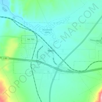
Name: Wells topographic map, elevation, terrain.
Location: Wells, Elko County, Nevada, 89835, United States (41.09325 -114.99295 41.12770 -114.91161)
Average elevation: 5,722 ft
Minimum elevation: 5,561 ft
Maximum elevation: 6,444 ft
Elko County trails, hiking, mountain biking, running and outdoor activities
Other topographic maps
Click on a map to view its topography, its elevation and its terrain.
Ruby Mountains
United States > Nevada > Elko County
The Ruby Mountains (Shoshoni: 'Duka Doya', meaning “Snowcapped”) are a mountain range, primarily located within Elko County with a small extension into White Pine County, in Nevada, United States. Most of the range is included within the Humboldt-Toiyabe National Forest. The range reaches a maximum…
Average elevation: 6,437 ft
Jackpot
United States > Nevada > Elko County
In addition to its casino industry, Jackpot has its own schools, golf course, and post office. Its elevation is approximately 5,200 feet (1,580 m) above sea level.
Average elevation: 5,364 ft