
Thank you for supporting this site ❤️
Make a donation
Make a donation
Gear up for your next adventure:
As an Amazon Associate, this site earns from qualifying purchases at no extra cost to you.
Nidrum topographic map
Click on the map to display elevation.
Thank you for supporting this site ❤️
Make a donation
Make a donation
Gear up for your next adventure:
As an Amazon Associate, this site earns from qualifying purchases at no extra cost to you.
About this map
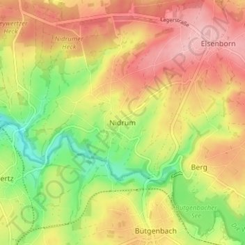
Name: Nidrum topographic map, elevation, terrain.
Location: Nidrum, Bütgenbach, Verviers, Liège, Wallonia, 4750, Belgium (50.42438 6.17682 50.46438 6.21682)
Average elevation: 1,883 ft
Minimum elevation: 1,644 ft
Maximum elevation: 2,080 ft
Thank you for supporting this site ❤️
Make a donation
Make a donation
Gear up for your next adventure:
As an Amazon Associate, this site earns from qualifying purchases at no extra cost to you.