Geolocate

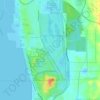
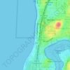
Carine topographic map

Click on the map to display elevation.

About this map
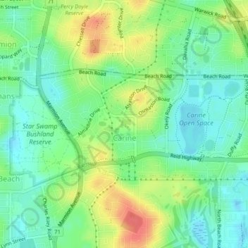
Name: Carine topographic map, elevation, terrain.

Location: Carine, Perth, Western Australia, 6020, Australia (-31.85949 115.76244 -31.84485 115.80132)

Average elevation: 85 ft

Minimum elevation: 13 ft

Maximum elevation: 200 ft

Other topographic maps

Click on a map to view its topography, its elevation and its terrain.
Mosman Beach

Australia > Western Australia > Perth

Average elevation: 30 ft

Canning river

Australia > Western Australia > Perth

Average elevation: 961 ft

Reabold Hill

Australia > Western Australia > Perth

Average elevation: 105 ft

Mundaring Weir

Australia > Western Australia > Perth

Average elevation: 607 ft

Adenia Lagoon

Australia > Western Australia > Perth

Average elevation: 30 ft

Lake Gwelup

Australia > Western Australia > Perth

Average elevation: 82 ft

Geo Lithgo Park

Australia > Western Australia > Perth

Average elevation: 92 ft

Lake Claremont

Australia > Western Australia > Perth

Average elevation: 72 ft

Woodford Park

Australia > Western Australia > Perth

Average elevation: 36 ft

Hatfield Park

Australia > Western Australia > Perth

Average elevation: 79 ft

Brittania Reserve

Australia > Western Australia > Perth

Average elevation: 82 ft

Alderley Park

Australia > Western Australia > Perth

Average elevation: 33 ft

Bold Park

Australia > Western Australia > Perth

Average elevation: 112 ft

Gear up for your next adventure:

🔭Stargazing Telescopes - Perfect for camping in low-light pollution areas shown on maps
🪓Survival Multi‑Tool - Versatile tool for camp and trail tasks
🪄Magnetic Compass - Accurate compass for navigation
🧭GPS Watch Accessories - Bands and chargers for GPS watches
🧦Merino Wool Socks - Moisture-wicking, blister-preventing socks for long treks

As an Amazon Associate, this site earns from qualifying purchases at no extra cost to you.