
Thank you for supporting this site ❤️
Make a donation
Make a donation
Gear up for your next adventure:
As an Amazon Associate, this site earns from qualifying purchases at no extra cost to you.
Lumutan topographic map
Click on the map to display elevation.
Thank you for supporting this site ❤️
Make a donation
Make a donation
Gear up for your next adventure:
As an Amazon Associate, this site earns from qualifying purchases at no extra cost to you.
About this map
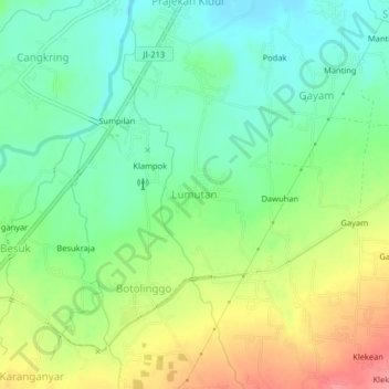
Name: Lumutan topographic map, elevation, terrain.
Location: Lumutan, Bondowoso, East Java, Java, Indonesia (-7.83683 113.96078 -7.79683 114.00078)
Average elevation: 354 ft
Minimum elevation: 243 ft
Maximum elevation: 528 ft
Thank you for supporting this site ❤️
Make a donation
Make a donation
Gear up for your next adventure:
As an Amazon Associate, this site earns from qualifying purchases at no extra cost to you.