
Thank you for supporting this site ❤️
Make a donation
Make a donation
Gear up for your next adventure:
As an Amazon Associate, this site earns from qualifying purchases at no extra cost to you.
Cimaferle topographic map
Click on the map to display elevation.
Thank you for supporting this site ❤️
Make a donation
Make a donation
Gear up for your next adventure:
As an Amazon Associate, this site earns from qualifying purchases at no extra cost to you.
About this map
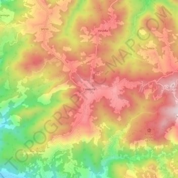
Name: Cimaferle topographic map, elevation, terrain.
Location: Cimaferle, Ponzone, Alessandria, Piemonte, Italia (44.53382 8.46404 44.57382 8.50404)
Average elevation: 1,821 ft
Minimum elevation: 902 ft
Maximum elevation: 2,477 ft
Thank you for supporting this site ❤️
Make a donation
Make a donation
Gear up for your next adventure:
As an Amazon Associate, this site earns from qualifying purchases at no extra cost to you.