
Make a donation
Gear up for your next adventure:
As an Amazon Associate, this site earns from qualifying purchases at no extra cost to you.
Parque Los Caobos topographic map
Click on the map to display elevation.
Make a donation
Gear up for your next adventure:
As an Amazon Associate, this site earns from qualifying purchases at no extra cost to you.
About this map
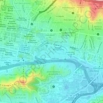
Name: Parque Los Caobos topographic map, elevation, terrain.
Average elevation: 2,966 ft
Minimum elevation: 2,818 ft
Maximum elevation: 3,363 ft
Make a donation
Gear up for your next adventure:
As an Amazon Associate, this site earns from qualifying purchases at no extra cost to you.
Other topographic maps
Click on a map to view its topography, its elevation and its terrain.
Conejo Blanco
Venezuela > Distrito Capital > Municipio Libertador > Caracas
Average elevation: 4,285 ft
Plaza Miranda
Venezuela > Distrito Capital > Municipio Libertador > Caracas
Average elevation: 3,022 ft
Jardines Quinta de Anauco
Venezuela > Distrito Capital > Municipio Libertador > Caracas
Average elevation: 3,182 ft
Make a donation
Gear up for your next adventure:
As an Amazon Associate, this site earns from qualifying purchases at no extra cost to you.
Plaza La Concordia
Venezuela > Distrito Capital > Municipio Libertador > Caracas
Average elevation: 3,005 ft
Bajada de Tazón
Venezuela > Distrito Capital > Municipio Libertador > Caracas
Average elevation: 3,314 ft
Plaza Caracas
Venezuela > Distrito Capital > Municipio Libertador > Caracas
Average elevation: 3,369 ft
Plaza Madariaga
Venezuela > Distrito Capital > Municipio Libertador > Caracas
Average elevation: 3,031 ft
Make a donation
Gear up for your next adventure:
As an Amazon Associate, this site earns from qualifying purchases at no extra cost to you.
Plaza Capuchinos
Venezuela > Distrito Capital > Municipio Libertador > Caracas
Average elevation: 3,035 ft
Plaza Madariaga
Venezuela > Distrito Capital > Municipio Libertador > Caracas
Average elevation: 3,031 ft
Make a donation
Gear up for your next adventure:
As an Amazon Associate, this site earns from qualifying purchases at no extra cost to you.
Castillo Blanco
Venezuela > Distrito Capital > Municipio Libertador > Caracas > Las Canoas
Average elevation: 4,085 ft