
Thank you for supporting this site ❤️
Make a donation
Make a donation
Gear up for your next adventure:
As an Amazon Associate, this site earns from qualifying purchases at no extra cost to you.
Teruel topographic map
Click on the map to display elevation.
Thank you for supporting this site ❤️
Make a donation
Make a donation
Gear up for your next adventure:
As an Amazon Associate, this site earns from qualifying purchases at no extra cost to you.
About this map
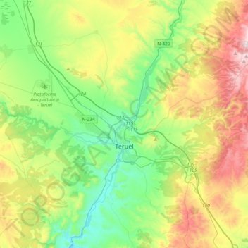
Name: Teruel topographic map, elevation, terrain.
Location: Teruel, Comunidad de Teruel, Teruel, Aragon, Spain (40.22730 -1.27848 40.51107 -0.95387)
Average elevation: 3,668 ft
Minimum elevation: 2,674 ft
Maximum elevation: 5,571 ft
Thank you for supporting this site ❤️
Make a donation
Make a donation
Gear up for your next adventure:
As an Amazon Associate, this site earns from qualifying purchases at no extra cost to you.